31st Annual Backcountry Benefit - September 12th - Tickets Available Here!

Forecast for the Logan Area Mountains

Trent Meisenheimer
Issued by Trent Meisenheimer on
Sunday morning, January 28, 2024
Today the avalanche danger is MODERATE, as human-triggered avalanches remain possible. People can trigger dangerous slab avalanches up to three feet deep and a couple hundred feet wide, failing on a buried persistent weak layer. Evaluate the snow and terrain carefully, and identify and avoid features of concern.
Low
Moderate
Considerable
High
Extreme
Learn how to read the forecast here
Special Announcements
Sign up for forecast region-specific text message alerts. You will receive messages about changing avalanche conditions, watches, and warnings...HERE.
Weather and Snow
Under cloudy skies, the mountain temperatures are about 10 degrees warmer this morning compared to yesterday. Current temperatures now range from 27-32 °F. Winds are blowing from the west direction at speeds of 10-20 mph with an occasional gust close to 30 mph on Logan Peak.
Today, we should see some sun filtered through clouds in the morning and afternoon hours, depending on your location. Temperatures will climb into the mid to upper 30s °F today ahead of a very weak storm that will move overhead around 5:00 PM. This small storm will bring a few snowflakes and clouds. High pressure will return on Monday and settle in until Thursday when we are expecting another storm that will last through the weekend.
Soft-settled powder on a supportable base exists in many aspects and elevations. Riding and turning conditions remain excellent.
Recent Avalanches
No new avalanches were reported from the Logan Area. However, two observers experienced a loud booming collapse of the snowpack while traveling. This remains a huge red flag as the snowpack collapsed and failed under their feet. It just wasn't on a steep enough hill to move anywhere. If you had titled that same slope above 30 degrees, you would triggered an avalanche. Check out local observations and avalanches HERE.
Ad
Avalanche Problem #1
Persistent Weak Layer
Type
Location
Likelihood
Size
Description
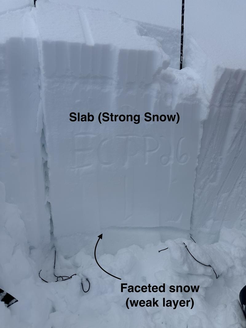
Today, human-triggered slab avalanches failing on a buried persistent weak layer could be large and life-threatening. During the last big storm, heavy snowfall and strong winds overloaded slopes plagued by a widespread persistent weak layer that formed throughout the December dry spell (see picture below).
Paige and I were in Tony Grove on Friday, and even though it's becoming less likely to trigger an avalanche, we still felt uncomfortable riding bigger, more consequential lines. We also avoided being under avalanche terrain as we do not trust our snowpack structure just yet.
If you do choose to ride steep avalanche terrain stack the odds in your favor by doing the following:
  • Ride one at a time in avalanche terrain and keep an eye on the person the entire time from a safe spot.
  • Choose a slope where the runout is free of trees, rocks, or cliffs. Smooth slope.
  • Do not stand or park underneath steep slopes, as avalanches can run long distances into the flats.
  • Be prepared for a rescue.
My advice: is leave the steep terrain alone for the weekend. Why ruin your day with an avalanche? Remember, sometimes even when you do everything right, the outcome can still be catastrophic. Let's give the snowpack a little more time to adjust and gain more strength. It won't be long before we can get into bigger terrain without the risk of triggering an avalanche that can kill you.
Additional Information
Suspect terrain includes areas with shallower snow (less than 150 cm) and a thinner slab layer (pictured below). On Friday, as we traveled around Tony Grove, it was easy to find areas that still propagate with extended column tests.
Photo: Height of snow 205 cm. Extended Column Test full propagation on 26 taps (ECTP26). This was on a mid-elevation (7,500') northeast-facing slope. Strong snow over weak snow is never a good setup.
General Announcements
-Come practice companion rescue with your backcountry partners at the Franklin Basin TH beacon training park. video HERE.
-For all questions on forecasts, education, Know Before You Go, events, online purchases, or fundraising: call 801-365-5522.
-To report an avalanche or submit an observation from the backcountry: go HERE.
-We will update this forecast by 7:30 AM tomorrow.
This forecast is from the U.S.D.A. Forest Service, which is solely responsible for its content. This forecast describes general avalanche conditions, and local variations always occur.