31st Annual Backcountry Benefit - September 12th - Tickets Available Here!

Forecast for the Moab Area Mountains

Eric Trenbeath
Issued by Eric Trenbeath on
Friday morning, January 19, 2024
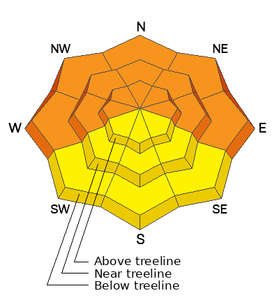
A CONSIDERABLE avalanche danger remains on steep slopes facing W-N-E. Deep and dangerous human triggered avalanches involving a buried persistent weak layer are likely in these areas.
A MODERATE avalanche danger exists on steep slopes facing SW-S-SE at all elevations. Human triggered avalanches failing on a buried persistent weak layer are possible.

A very weak, and unstable snowpack has developed and this situation is likely to be with us for awhile. Cultivate the mindset that avalanche terrain is off limits and keep your slope angles less than 30 degrees.
Low
Moderate
Considerable
High
Extreme
Learn how to read the forecast here
Special Announcements
Our Backcountry 101 class is full! Thanks to Moab Gear Trader for sponsoring this course!
Sign up for forecast region-specific text message alerts. You will receive messages about changing avalanche conditions, watches, and warnings.
Follow us on Instagram @utavy_moab
Road Conditions: The Geyser Pass Road was plowed yesterday. The surface is snowpacked. AWD with good tires recommended.
Grooming: Matt rolled out all trails yesterday. LUNA volunteers will be up again today to fine tune and set classic track.
Weather and Snow
6:00 a.m. Snow and Weather Data
24 Hour Snow 0" 72 Hour Snow 4" Season Total Snow 81" Base Depth at Gold Basin 36"
Winds on Pre-Laurel Peak: NNW 10-15 Temp 22˚ F

Weather
A weak and dirty ridge of high pressure will push through the region today. By Saturday, we'll see the first in a series of weak shortwaves moving through the Intermountain West. This will keep us under an unsettled weather pattern though mid next week but with fairly insignificant snowfall. Today look for partly sunny skies, light westerly winds, and high temps at 10,000' in the low 30's. On Saturday we should see partly sunny skies in the morning and increasing clouds throughout the day. A chance for snow showers develops Saturday night continuing through Sunday.
General Conditions
4" of new snow yesterday and minimal wind freshened up turning and riding conditions but it's still a bit tenuous out there, especially on sleds where trenching into the weak, sugary snow under the January slab remains an obstacle to carefree riding. It's also still quite thin in many areas. Yesterday, Dave Garcia and I toured up toward the Burro Pass/Mann's Peak area and we continued to experience widespread collapsing of the snowpack. This red flag sign of instability is the result of a person's weight collapsing the slab over a weak layer. The danger is greatest on steep, wind loaded, northerly facing slopes, but the persistent weak layer also exists on southerly aspects. Avoiding slopes steeper than 30 degrees remains the only safe strategy right now.
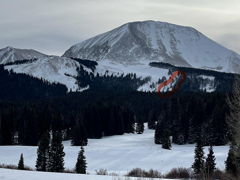
Conditions can be misleading out there. While many areas above treeline are stripped of snow, a very real avalanche problem exists on any steep slope that has snow. Northerly facing slopes near treeline, where wind drifted snow has accumulated are particularly dangerous. Winter Rescue Team commander Scott Sole observed this natural avalanche yesterday that probably occurred last weekend.
Snowpack and Weather Data
Gold Basin Storm Stake (10,000')
Gold Basin SNOTEL site (10,000')
SNOTEL site near Geyser Pass Winter Trailhead (9600')
Wind Station on Pre-Laurel Peak (11,400')
NWS forecast for the La Sal Mountains.
Recent Avalanches
This large avalanche in Horse Creek off the Laurel Ridge was remotely triggered by Dave Garcia on Monday. Normally we would consider this old news except for the fact that you can still trigger one like it. This avalanche is about 1,500' wide with an average depth of 4' and a maximum depth of 6.5'. Get the full details here.
Ad
Avalanche Problem #1
Persistent Weak Layer
Type
Location
Likelihood
Size
Description
A slab of cohesive snow now exists above a persistent weak layer of faceted snow on all aspects and elevations. Collapsing and whumphing continue to be widespread. This red flag sign of instability demonstrates how easily the slab fails under a person's weight. On northerly facing slopes, thick hard slabs of wind-drifted snow rest on top of this weak layer, and they are hanging in the balance just waiting for a trigger. Once triggered, these avalanches will break deep and wide, and will be un-survivable. On southerly aspects stabilty tests also demonstrate slab failure with propagation. These avalanches are more stubborn to trigger, and won't be quite as large, but make no mistake, they are not to be trifled with. Avoidance of slopes steeper than 30 degrees is the only safe strategy right now.
The video below illustrates unstable conditions with a slab failing on a weak layer on a SE aspect. An extended column test produced resuslt of ECTP23.
Additional Information
To fulfill our mission, the UAC relies on our amazing backcountry community. Your support helps pay for the daily avalanche forecast, free awareness presentations across the state, and new tools like the new Avalanche and Observation Explorer. As we welcome the new year, please consider donating to the UAC.
General Announcements
This forecast is from the U.S.D.A. Forest Service, which is solely responsible for its content. This forecast describes general avalanche conditions and local variations always occur.