31st Annual Backcountry Benefit - September 12th - Tickets Available Here!

Forecast for the Moab Area Mountains

Dave Garcia
Issued by Dave Garcia on
Tuesday morning, January 30, 2024
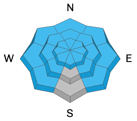
The overall avalanche danger today is MODERATE. Dangerous human-triggered slab avalanches 2-6 feet deep failing on a buried persistent weak layer remain possible on most aspects. The odds of triggering a slide have dropped, but the consequences have not.
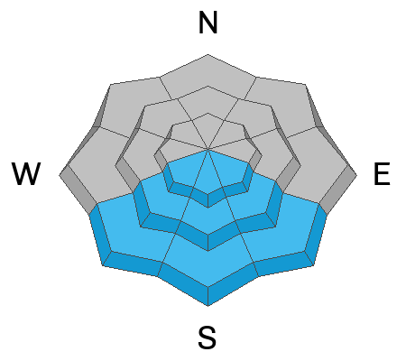
Unseasonably warm temperatures and strong sunshine will cause wet-loose avalanches to be possible on steep solar aspects.
Low
Moderate
Considerable
High
Extreme
Learn how to read the forecast here
Special Announcements
Road Conditions: The Geyser Pass Road was plowed on Monday. The road remains snow covered, AWD and good tires are recommended.
Grooming: Matt groomed all trails and set classic track on Sunday.
Check out this excellent blog post by Eric Trenbeath about a Moderate danger with a persistent weak layer.
Weather and Snow
6:00 a.m. Snow and Weather Data
24 Hour Snow 0" 72 Hour Snow 0" Season Total Snow 95" Base Depth at Gold Basin 40"
Winds on Pre-Laurel Peak: ENE 13 G 16 Temp 25˚ F

Weather
A ridge of high pressure continues to dominate the Western U.S. Today will be a repeat of yesterday with highs near 40 degrees and sunny skies. Light winds will blow out of the SE at 5-10 mph. The warm sunny conditions continue on Wednesday, and we will see things change on Thursday. Clouds build on Thursday with snow showers developing late in the day. We are still on track for a snowy weekend - stay tuned.
General Conditions
Today will be another beautiful day in the mountains. The wind continues to be well behaved and the skiing remains excellent. Solar aspects will be crusted over this morning, but they should soften up later this afternoon thanks to above-average temperatures and plenty of sunshine. Wet-Loose avalanches are possible today, and backcountry travelers will need to look out for signs of warming. There is plenty of soft snow to be found on the polar aspects. Many slopes have buried persistent weak layers that can still produce large slab avalanches. It is easy to forget these weak layers exist, collapsing and whumphing have stopped, the skiing is excellent, temps are warm, and skies are blue. Make no mistake, dangerous avalanches are still possible. These avalanches will average two feet deep. Leeward slopes that have been previously loaded by wind-drifted snow have the potential to break up to six feet deep.
I toured around Gold Basin yesterday, see my observation here.
Snowpack and Weather Data
Gold Basin Storm Stake (10,000')
Gold Basin SNOTEL site (10,000')
SNOTEL site near Geyser Pass Winter Trailhead (9600')
Wind Station on Pre-Laurel Peak (11,400')
NWS forecast for the La Sal Mountains.
Recent Avalanches
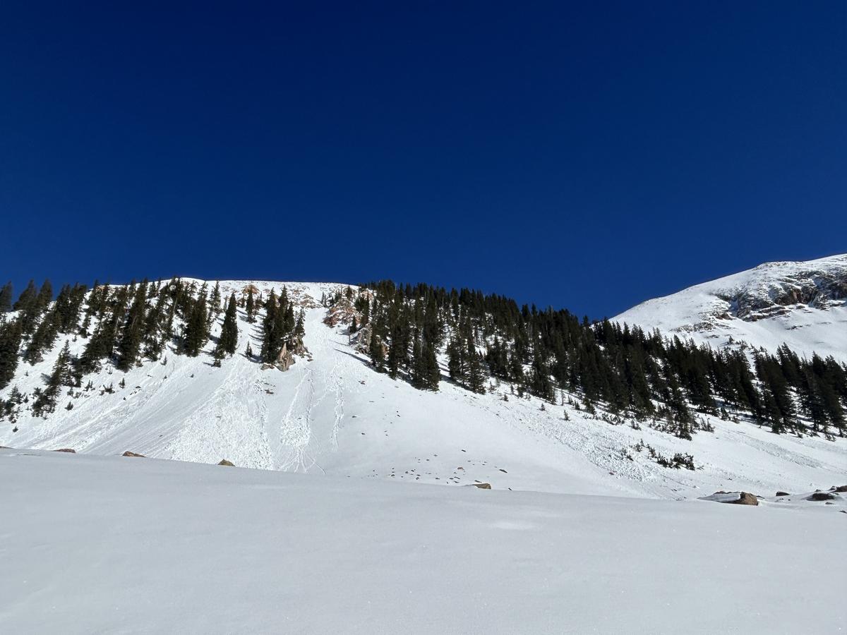
These small, wet-loose avalanches were observed on SW facing slopes around 11,000 ft on Monday. While they look small, these avalanches entrained enough snow to knock you over and push you around.
Ad
Avalanche Problem #1
Persistent Weak Layer
Type
Location
Likelihood
Size
Description
A buried persistent weak layer of faceted snow exists on most aspects. This layer is buried roughly two feet below the surface and is easily found with your shovel. Outward signs of instability like collapsing and cracking are no longer obvious. The odds of triggering an avalanche have dropped, but the consequences remain the same. These weak layers can still produce deep and dangerous slab avalanches. You are most likely to trigger an avalanche in areas with a thin snowpack, like slopes that were heavily scoured by winds before the January storms laid down a slab. Slopes that have previously avalanched are also suspect. Any steep, thin, rocky area is a likely trigger point.
If you choose to step into avalanche terrain, stack the odds in your favor by choosing terrain with clean run outs. Choose terrain that gradually transitions back to lower angles and avoid steep slopes that end abruptly in gullies or terrain traps. Avoid skiing above cliff bands or stands of trees that you could be raked through. Think about the shape of the terrain and where you would go if an avalanche occurs. Remember at Moderate danger, human-triggered avalanches remain possible.
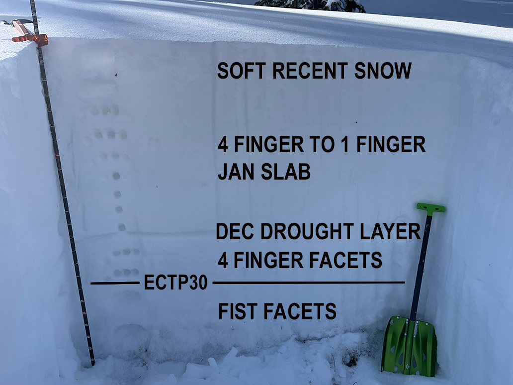
This profile is from a NE facing slope at 11,250'. The top few inches are soft snow that fell over the past week. The 4 finger to 1 finger slab is the rest of the snow that fell in January. The December drought layer is becoming more dense, and did not produce a failure. The 4 finger facet layer beneath is also gaining strength. The weakest snow remains near the ground where fist density facets can be found. An extended column test produced results of ECTP 30 at the top of this layer. What this tells us is that in deeper snowpack areas, it is becoming harder for the weight of a person to affect buried weak layers, but if they did, the avalanche would be deep and nearly to the ground. In shallower snowpack areas, it is easier to affect this buried weak layer, and human triggered avalanches are much more likely.
Avalanche Problem #2
Wet Snow
Type
Location
Likelihood
Size
Description
The mountains got a solid re-freeze last night, so you can travel safely on the solar aspects this morning. Avoiding wet-loose avalanches is all about timing. As the day progresses look for signs that the snow is becoming too warm. Signs of wet activity include pin-wheels and roller balls, unsupportable snow, and wet saturated snow. When you see these warning signs, it is time to change aspects.
Additional Information
Want some more insight into the La Sal Mountains as well as the communal impacts of a tragic avalanche? Check out the latest UAC podcast with forecaster Eric Trenbeath where he discusses the range, it's often treacherous snowpack, and how the devastating avalanche in February, 1992, affected the Moab community.
Our avalanche beacon checker sign and beacon training park are up and running. A huge thanks to Talking Mountain Yurts for sponsoring those this season!
Sign up for forecast region-specific text message alerts. You will receive messages about changing avalanche conditions, watches, warnings and road plowing closures.
Follow us on Instagram @utavy_moab
General Announcements
This forecast is from the U.S.D.A. Forest Service, which is solely responsible for its content. This forecast describes general avalanche conditions and local variations always occur.