31st Annual Backcountry Benefit - September 12th - Tickets Available Here!

Forecast for the Moab Area Mountains

Dave Garcia
Issued by Dave Garcia on
Tuesday morning, February 20, 2024
The avalanche danger is MODERATE. The likelihood continues to decrease, but deep and dangerous human-triggered avalanches failing on a buried persistent weak layer remain possible on steep slopes that face W-N-E-SE with the greatest danger existing on slopes facing NW-N-E. If you venture into avalanche terrain, minimize your risk by avoiding thinner snowpack areas, rocky, radical terrain, and slopes with complex terrain features.
Strong Southerly winds have produced fresh slabs of wind-drifted snow above treeline where it is possible to trigger small avalanches on slopes that face NW-N-E.

A generally LOW danger exists on slopes facing S-SW.
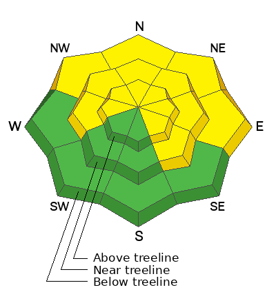
Low
Moderate
Considerable
High
Extreme
Learn how to read the forecast here
Special Announcements
We are seeking a passionate individual to join us as Executive Director of the nonprofit Utah Avalanche Center. Click here for more information.
Road Conditions: The Geyser Pass Road is plowed but snowpacked and slick!
Grooming: LUNA groomed Gold Basin through Geyser Pass and set classic track on Sunday.
Weather and Snow
6:00 a.m. Snow and Weather Data
24 Hour Snow 0" 72 Hour Snow 2" Season Total Snow 132" Depth at Gold Basin 49"
Winds on Pre-Laurel Peak: SSE 13-17 Temp 32° Percent of Normal: 100%

Weather
Strong winds blew overnight out of the SSE. Winds will shift to the SSW today, and continue to blow 15-25 mph. Moisture delivered by an atmospheric river will generate accumulating snowfall across the Northern and central mountains through Thursday. The highest snowfall amounts will be concentrated across points North. Locally, we will see increasing clouds, blustery SW winds, and light flurries with no accumulation today. We may pick up 1-3" of snow on Wednesday.
General Conditions
Despite the strong winds, good skiing can still be found on sheltered terrain at the mid-elevations. In my travels yesterday, I found soft turns on the Northerlies in settled powder. The recent 2 inches of snow and strong winds have even created some unexpected and fun "wind-buff" conditions on the Southerlies. I observed shallow slabs of wind-drifted snow forming in isolated areas on the lee side of the highest elevation ridge lines. I would expect these small slabs to be sensitive today if you happen to be poking around in the alpine. These slabs of wind-drifted snow exist in the exact places I am currently avoiding. Steep and rocky alpine terrain remains the most likely place to trigger an avalanche failing on a deeply buried persistent weak layer of facets. It is becoming increasingly more difficult to trigger an avalanche on this weak layer, but you are most likely to trigger one on slopes with a shallow snowpack. You can stack the odds in your favor by avoiding complex terrain features, and skiing in areas with deep snow. Grab your shovel, or simply probe around. I have been finding safe and fun skiing on many slopes at the mid-elevations with a depth of 200 cm or more.
See the most recent observations here.
Check out this video for a discussion of our current, "Low probability - high consequence" scenario.
Snowpack and Weather Data
Gold Basin Storm Stake (10,000')
Gold Basin SNOTEL site (10,000')
SNOTEL site near Geyser Pass Winter Trailhead (9600')
Wind Station on Pre-Laurel Peak (11,400')
NWS forecast for the La Sal Mountains.
Recent Avalanches
See the full list of avalanche activity here
Ad
Avalanche Problem #1
Persistent Weak Layer
Type
Location
Likelihood
Size
Description
Our main avalanche problem continues to be the persistent weak layers (PWL) that formed in November and December. We saw widespread natural avalanche activity on these layers at the beginning of the month. Our last storm wrapped up on February 9th. With each passing day, it becomes less likely to trigger an avalanche on the PWL, but any avalanche triggered would be life-threatening. At this point, you will not get any feedback from the snow, collapsing and cracking are long gone. You may start seeing tracks in bigger, more consequential terrain. It is important to remember that tracks are not an indication of stability. Hard slab avalanches failing on persistent weak layers are often triggered by the third, sixth, or even tenth rider on a slope, wiping out all previous tracks. You should evaluate each slope on an individual basis. Aim to ride in areas with a deep snowpack. Avoid steep, rocky terrain, thinner areas along slope margins, and steep, blind roll overs or convexities. These are all likely trigger points.
Avalanche Problem #2
Wind Drifted Snow
Type
Location
Likelihood
Size
Description
Strong Southerly winds have deposited shalllow, soft slabs of wind-drifted snow on the leeward side of the highest elevation ridge lines. These slabs will be sensitive to the weight of a skier or rider today. You can easily manage this problem by avoiding rounded, pillowy-looking pieces of snow in alpine terrain.
Additional Information
Want some more insight into the La Sal Mountains as well as the communal impacts of a tragic avalanche? Check out the latest UAC podcast with forecaster Eric Trenbeath where he discusses the range, it's often treacherous snowpack, and how the devastating avalanche in February, 1992, affected the Moab community.
Our avalanche beacon checker sign and beacon training park are up and running. A huge thanks to Talking Mountain Yurts for sponsoring those this season!
Sign up for forecast region-specific text message alerts. You will receive messages about changing avalanche conditions, watches, warnings and road plowing closures.
Follow us on Instagram @utavy_moab
General Announcements
This forecast is from the U.S.D.A. Forest Service, which is solely responsible for its content. This forecast describes general avalanche conditions and local variations always occur.