31st Annual Backcountry Benefit - September 12th - Tickets Available Here!

Forecast for the Moab Area Mountains

Eric Trenbeath
Issued by Eric Trenbeath on
Monday morning, February 26, 2024
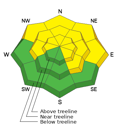
The overall danger remains MODERATE. Although increasingly unlikely, human-triggered avalanches failing on a buried persistent weak layer remain possible on steep slopes that face W-N-E-SE. The danger is most prominent on steep, northerly aspects. You are most likely to trigger an avalanche in thinner snowpack areas. You can reduce your risk by avoiding steep, rocky areas and slopes with complex terrain features.
Strong southwesterly winds may begin to blow and drift snow into fresh slabs on leeward, northerly aspects today. Expect the problem to become more widespread by tomorrow when new snow overnight has accumulated.
A generally LOW danger exists on slopes facing S-SW.
Low
Moderate
Considerable
High
Extreme
Learn how to read the forecast here
Special Announcements
We are seeking a passionate individual to join us as Executive Director of the nonprofit Utah Avalanche Center. Click here for more information.
Road Conditions: The Geyser Pass Road is plowed but snowpacked and slick!
Grooming: Trails have not been groomed in over a week.
Weather and Snow
6:00 a.m. Snow and Weather Data
24 Hour Snow 0" 72 Hour Snow 0" Season Total Snow 132" Depth at Gold Basin 48"
Winds on Pre-Laurel Peak: SW 20-25 G33 Temp 30° Percent of Normal: 98%

Weather
Hold on to your hats. Winds from the SW ramped up overnight blowing in the 20-25 mph range with gusts in the 30's. They'll continue to increase today as the first wave in an approaching storm system blows through. Unfortunately, it looks to be all huff and puff and no fluff for us today, and we'll see cloudy skies, continued warm temperatures and windy conditions. The second wave arrives this evening with even stronger winds and plummeting temperatures. We should get a shot of cold smoke out of this but amounts aren't too impressive. I'm still holding on to about 6". The rest of the week will be sunny and dry with gradually warming temperatures.
General Conditions
It's going to be a little rugged out there today with flat light, windy conditions, and a variety of snow surfaces to contend with. Sheltered, northerly aspects harbor the best chance for finding soft snow. With southerly facing slopes well crusted over, there isn't much snow available for transport, but with these wind speeds, we may still see some snow being blown and drifted into fresh slabs on leeward slopes. As snow begins to accumulate tonight, expect windslabs to become more widespread by tomorrow. A weak layer of faceted snow at the base of the snowpack remains our primary concern. The likelihood of triggering a deep avalanche down to this weak layer has decreased significantly, but keep the odds in your favor by avoiding areas of steep, rocky, radical terrain, or slopes with complex terrain features. Thinner snowpack areas remain suspect where your weight can much more easily affect the weak layer. We are getting reports of people pushing into steep, consequential terrain without incident, but before you do this, pull out your shovel, or simply probe around. I'd personally like to see close to 200 cms of snow before I'd feel good about skiing something steep.
We received a couple observations over the weekend. See the most recent observations here.
I took a trip around to the east side yesterday to see how things were holding up and was pleasantly surprised to see how much snow was still hanging around on southerly aspects and at lower elevations over there.
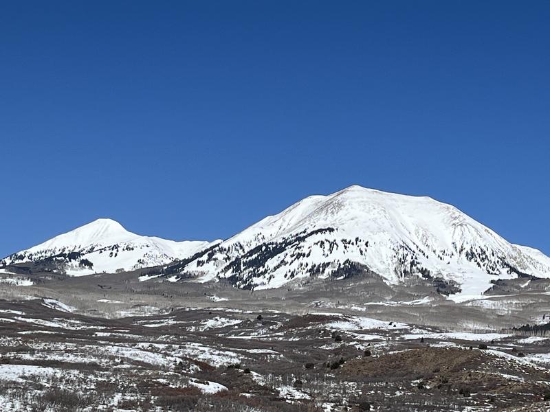
The massive SE face of mighty Mount Peale on the right with some rocks exposed on due S. The SE face of Mount Tukuhnikivatz in the distance looks well covered.
Snowpack and Weather Data
Gold Basin Storm Stake (10,000')
Gold Basin SNOTEL site (10,000')
SNOTEL site near Geyser Pass Winter Trailhead (9600')
Wind Station on Pre-Laurel Peak (11,400')
NWS forecast for the La Sal Mountains.
Ad
Avalanche Problem #1
Persistent Weak Layer
Type
Location
Likelihood
Size
Description
Persistent weak layers (PWL) of faceted snow that formed in November and December remain our primary concern. The likelihood of triggering an avalanche on a deeply buried PWL continues to decrease, but it is still possible. We are now in a low likelihood, high consequence scenario. If you are stepping out into avalanche terrain, evaluate each slope on an individual basis. Aim to ride in areas with a deep snowpack. Avoid steep, rocky terrain, thinner areas along slope margins, and steep, blind rollovers or convexities. These are all likely trigger points.
Avalanche Problem #2
Wind Drifted Snow
Type
Location
Likelihood
Size
Description
There isn't much loose snow available for transport but winds of these speeds may begin to strip and erode crusts on south facing slopes, while building fresh slabs on northerly aspects. Cross-loading may be possible on slopes facing west or southeast. Fresh slabs of wind drifted are often recognizable by their smooth, rounded appearance, and cracking is a sign of instability. Slabs form on the leeward sides of ridge crests and terrain features such as gully walls, sub-ridges, or rock outcroppings. Expect this problem to become more widespread by tomorrow as new snow accumulates.
Additional Information
Want some more insight into the La Sal Mountains as well as the communal impacts of a tragic avalanche? Check out the latest UAC podcast with forecaster Eric Trenbeath where he discusses the range, it's often treacherous snowpack, and how the devastating avalanche in February, 1992, affected the Moab community.
Our avalanche beacon checker sign and beacon training park are up and running. A huge thanks to Talking Mountain Yurts for sponsoring those this season!
Sign up for forecast region-specific text message alerts. You will receive messages about changing avalanche conditions, watches, warnings and road plowing closures.
Follow us on Instagram @utavy_moab
General Announcements
This forecast is from the U.S.D.A. Forest Service, which is solely responsible for its content. This forecast describes general avalanche conditions and local variations always occur.