31st Annual Backcountry Benefit - September 12th - Tickets Available Here!

Forecast for the Moab Area Mountains

Eric Trenbeath
Issued by Eric Trenbeath on
Thursday morning, March 28, 2024
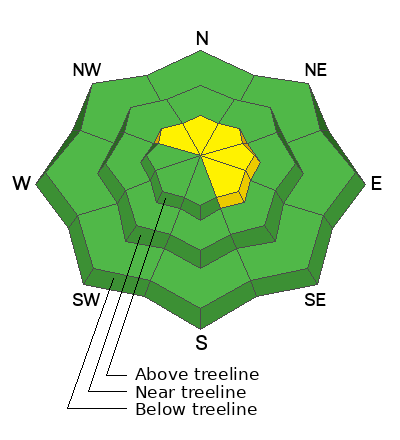
Most terrain has LOW danger. An isolated or MODERATE danger exists on steep, wind drifted slopes above treeline that face NW-NE-SE. If you are looking to ski in the alpine, avoid steep slopes that have pillowy, or wavy looking deposits of wind drifted snow, especially in areas of consequential terrain.
With partly sunny skies and warming temperatures we may see some minor, loose, wet avalanche activity on sun exposed slopes. Signs of instability incliude rollerballs, pinwheels, and sloppy, wet snow.
Low
Moderate
Considerable
High
Extreme
Learn how to read the forecast here
Special Announcements
Road Conditions: The Geyser Pass Road is plowed and is mostly down to the dirt. It gets muddy and sloppy later in the day.
Grooming: Trails were packed into Gold Basin yesterday.

Support the UAC website backend platform rebuild to ensure the ongoing security of the website and the data stored on the site rebuild by donating to our spring campaign. Save lives by making a donation today! HERE
Weather and Snow
6:00 a.m. Snow and Weather Data
24 Hour Snow 0" 72 Hour Snow 1" Season Total Snow 182" Depth at Gold Basin 66"
Winds on Pre-Laurel Peak: SW 20-30 G 38 Temp 27° F Percent of Normal: 133%

Weather
Winds from the SW began ramping up a little after midnight and I'm afraid they are here to stay. Following brief ridging today, we're headed into a prolonged period of unsettled weather lasting at least into early next week. Action for the next few days will be focused on points north, but we'll get plenty of wind and increasing clouds today with high temperatures rising into the mid 30's at 10,000'. We'll see more clouds and ever increasing SW winds through Saturday. By Sunday, a deep low pressure system moves into the desert Southwest bringing us our next chance for snow. Stay tuned.
General Conditions
It's been quite a run the last few days with 13" of snow falling Sunday night into Monday, followed by cool temperatures, clouds, light to moderate winds, and another 1"-3" on Tuesday. Yesterday was primo with mostly sunny skies, continued cold temperatures, and great powder skiing and riding. NW winds early in the storm built slabs of drifted snow on leeward slopes above treeline, while alternately scouring some windward slopes. In our travels through the high country yesterday, we found some wind affected snow on W-NW aspects above treeline, and we observed pillowy looking, wind loaded slopes, primarily facing N-NE on the highest peaks. If you climb up into that zone, you'll want to continue to be wary of wind slabs. A strong sun dampened the surface yesterday and sun exposed slopes will be crusted over, but you'll still be able to find good powder snow on northerly aspects, with the best snow conditions existing right around treeline or just above.
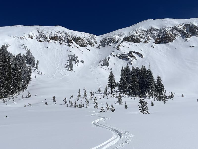
In the photo below you can see where the snow gets good in this NW facing couloir. The upper portion above the choke was pretty wind wrecked. It got progressively better after that. The low angle run out was getting damp and will be crusted over today.
For a recap of condtions earlier this week, check out this video Dave put together:
Snowpack and Weather Data
Gold Basin Storm Stake (10,000')
Gold Basin SNOTEL site (10,000')
SNOTEL site near Geyser Pass Winter Trailhead (9600')
Wind Station on Pre-Laurel Peak (11,400')
NWS forecast for the La Sal Mountains.
Recent Avalanches
Click here to see the La Sal avalanche database.
Ad
Avalanche Problem #1
Wind Drifted Snow
Type
Location
Likelihood
Size
Description
NW winds have deposited slabs of wind-drifted snow between 18"-24" deep on many slopes above treeline. The distribution is somewhat spotty with some slopes being heavily drifted, while adjacent slopes are soft and fluffy, or even a little scoured. The bulls-eye location for this problem seems to be on slopes facing NE-E-SE. Most of this drifting occured between Sunday and Tuesday, and these slabs are gaining strength and will be stubborn to release today, but I would continue to be wary of wind drifted slopes, especially in consequential terrain. In addition, strong SW winds may be able to whip up a fresh round of wind slabs in these same areas. South faces are crusted over, and there isn't much loose snow available for transport, but be on the lookout for fresh deposits of wind drifted snow.
A note about near-treeline terrain: recent wind-drifted snow is not widespread near-treeline, but some of our near-treeline terrain behaves like alpine terrain, meaning it is subjected to the same loading patterns. If you are getting into big, steep, open slopes near the treeline, continue to be on the lookout for wind-drifted snow.
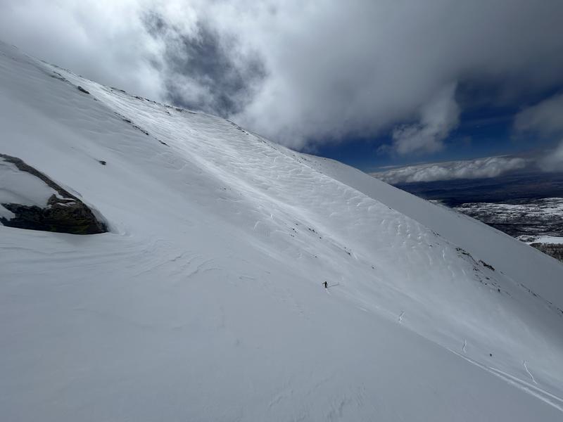
In the photo below, you can see some wind-loaded slopes in the background behind the skier. The skier is using a subtle aspect change to avoid the wind drifts. Aspect is key right now.
Additional Information
Want some more insight into the La Sal Mountains as well as the communal impacts of a tragic avalanche? Check out the latest UAC podcast with forecaster Eric Trenbeath where he discusses the range, it's often treacherous snowpack, and how the devastating avalanche in February, 1992, affected the Moab community.
Our avalanche beacon checker sign and beacon training park are up and running. A huge thanks to Talking Mountain Yurts for sponsoring those this season!
Sign up for forecast region-specific text message alerts. You will receive messages about changing avalanche conditions, watches, warnings and road plowing closures.
Follow us on Instagram @utavy_moab
General Announcements
This forecast is from the U.S.D.A. Forest Service, which is solely responsible for its content. This forecast describes general avalanche conditions and local variations always occur.