31st Annual Backcountry Benefit - September 12th - Tickets Available Here!

Forecast for the Moab Area Mountains

Eric Trenbeath
Issued by Eric Trenbeath on
Tuesday morning, April 2, 2024
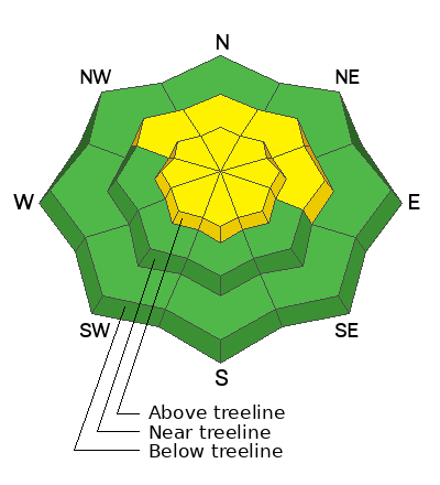
A MODERATE avalanche danger exists on steep wind loaded slopes near treeline and above that face NW-N-NE-E. In these areas, human triggered avalanches involving slabs of wind drifted snow, 12"-18" deep are possible. Shallower slabs of drifted snow may also be present on southerly aspects above treeline. Look for them on the leeward side of ridge crests and terrain features such as gully walls and sub-ridges.
Out of the wind zone, the avalanche danger is generally LOW. Small avalanches on isolated terrain features are possible. This includes the potential for small, loose wet avalanches on sun exposed slopes as the day heats up.
Low
Moderate
Considerable
High
Extreme
Learn how to read the forecast here
Special Announcements
Road Conditions: The lower end of the Geyser Pass road is now mostly dry dirt. Melting snow on the upper end will make for sloppy and muddy conditions later in the day.
Grooming: The trail into Gold Basin was rolled out yesterday.
Weather and Snow
6:00 a.m. Snow and Weather Data
24 Hour Snow 0" 72 Hour Snow 7" Season Total Snow 190" Depth at Gold Basin 66"
Winds on Pre-Laurel Peak: NE 10-20 G 33 Temp 16° F Percent of Normal: 135%

Weather
Late yesterday afternoon, winds from the NW picked up a bit blowing in the 15-20 mph range for about six hours before backing off. Around 3:00 a.m. they shifted to northeasterly and picked up speed. We should continue to see blustery NE winds throughout the day averaging 20-30 mph along ridge tops decreasing slightly by afternoon. Otherwise, look forward to sunny skies and warm temps in the upper 30's as high pressure builds over the region. Wednesday should see clear and mostly calm conditions. By Thursday we should start to see a few clouds and increasing southerly winds ahead of the next Pacific storm system slated to arrive around Friday night.
General Conditions
Sunday's 7" of new snow has greatly improved conditions in some areas. The snow came in with strong SW winds gusting as high as 60 mph which blew and drifted snow into slabs 12"-18" deep on northerly aspects while alternately scouring, and occasionally cross-loading slopes on the south side of the compass. Slabs will be more stubborn to trigger today, but avoiding steep, wind drifted slopes, especially those on the north side of the compass is still a good policy. For the best turning and riding conditions you'll want to seek out sheltered, northerly aspects out of the wind zone. Conditions are quite good in these areas. Expect daytime heating to affect sun exposed slopes today. Signs of instability include rollerballs, pinwheels, and sloppy wet snow. Stay off of and out from under steep slopes when these signs are present.
Snowpack and Weather Data
Gold Basin Storm Stake (10,000')
Gold Basin SNOTEL site (10,000')
SNOTEL site near Geyser Pass Winter Trailhead (9600')
Wind Station on Pre-Laurel Peak (11,400')
NWS forecast for the La Sal Mountains.
Recent Avalanches
Click here to see the La Sal avalanche database.
Ad
Avalanche Problem #1
Wind Drifted Snow
Type
Location
Likelihood
Size
Description
Strong SW winds blew and drifted snow with a vengeance on Sunday creating slabs 12"-18" deep on slopes facing NW-N-NE-E near treeline and above, with some cross-loading possible on upper elevation slopes facing the south side of the compass. In addition, blustery, NE winds will likely form some shallow, fresh slabs above treeline today. Look for fresh deposits on the leeward sides of gully walls, sub-ridges, and rocky outcrops. Deeper drifts that formed during Sunday will be more stubborn to trigger today and you may have to get further down slope before they release. The best policy is to continue to avoid steep, wind drifted northerly aspects, especially on the bigger, more consequential terrain above treeline. Time, and warm temperatures today should help stabilize this problem.
Strong winds blowing and drifting snow on Sunday:
Additional Information
Want some more insight into the La Sal Mountains as well as the communal impacts of a tragic avalanche? Check out the latest UAC podcast with forecaster Eric Trenbeath where he discusses the range, it's often treacherous snowpack, and how the devastating avalanche in February, 1992, affected the Moab community.
Our avalanche beacon checker sign and beacon training park are up and running. A huge thanks to Talking Mountain Yurts for sponsoring those this season!
Sign up for forecast region-specific text message alerts. You will receive messages about changing avalanche conditions, watches, warnings and road plowing closures.
Follow us on Instagram @utavy_moab
General Announcements
This forecast is from the U.S.D.A. Forest Service, which is solely responsible for its content. This forecast describes general avalanche conditions and local variations always occur.