31st Annual Backcountry Benefit - September 12th - Tickets Available Here!

Forecast for the Ogden Area Mountains

Trent Meisenheimer
Issued by Trent Meisenheimer on
Wednesday morning, January 31, 2024
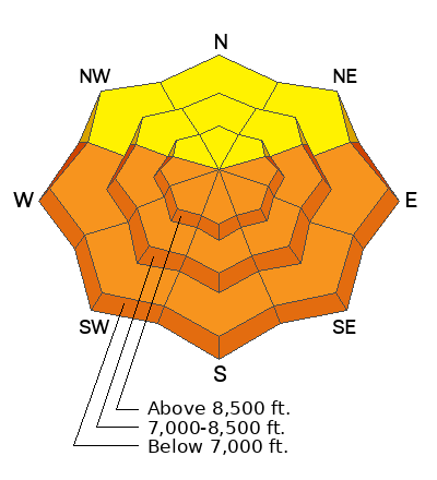
Today, there is a MODERATE avalanche danger that exists on steep west to north to southeast facing slopes for triggering a 2-5' thick hard slab avalanche that fails on a buried persistent weak layer of faceted snow.
With clear skies and warm temperatures, the danger for wet avalanches will rise to CONSIDERABLE on all steep sunny (as well as low to mid-elevation shady) slopes.
Low
Moderate
Considerable
High
Extreme
Learn how to read the forecast here
Weather and Snow
Under clear skies, the mountain temperatures are inverted and remain on the warmer side of normal, ranging from 28 °F at 6,000' to 33°F at 9,200'. Winds have picked up just a little this morning and now blow from the south at 15-25 mph, gusting into the 30s across the upper elevations.
Today, high pressure will slowly shift to the east as a large closed low currently spins off the Oregon Coast. As this next storm system moves in, we will see a slight increase in southerly winds today ahead of this storm. We will have plenty of sunshine in the morning and afternoon, with daytime mountain temperatures climbing into the upper 30s and low 40s °F. Later in the day, we could see an increase in cloud cover as the storm moves towards us.
This closed low will change the weather pattern, and tomorrow into Friday, we will see the return to winter with 16-24 inches of new snow possible.
Recent Avalanches
Since Sunday, there have been three avalanches that should catch your attention. Each avalanche is large enough to catch, carry, and kill a human (destructive size 2). Each avalanche failed on a persistent weak layer of faceted snow buried 2-5 feet deep.
On top of the persistent weak-layer avalanches, we had an extensive wet avalanche cycle on sunny slopes from strong sunshine and very warm temperatures. This ranged from roller balls to wet loose avalanches, followed by wet slab avalanches failing on a persistent weak layer of faceted snow. Timpanogos, Provo Peak, and Cascade Ridge went through a widespread natural wet slab cycle late in the day. Photos HERE. Video HERE. More of the same today.
Ad
Avalanche Problem #1
Persistent Weak Layer
Type
Location
Likelihood
Size
Description
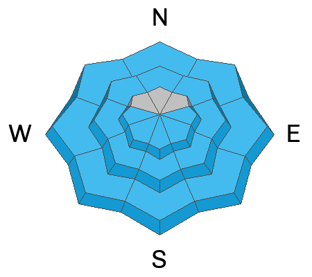
On January 4, a widespread persistent weak layer of faceted snow was buried and preserved. Since then, we've had several storms, which have built a strong hard slab of snow over this weak layer. This weak layer is now buried roughly 2-5 feet deep. At first, this layer was very sensitive and the avalanche danger was in your face. You could sneeze and trigger an avalanche.
So what's changed? Well, "The Likelihood" meaning the possibility of triggering an avalanche, has gone down. BUT, the consequence of the avalanche has remained the same.
I get it; there are tracks everywhere. It's easy to get lured into the terrain. But remember, faceted snow with a strong slab is no joke, and in my opinion, it's not worth messing with. These are bone-crushing avalanches that will break all around you with no escape. Hey, I want to ride big terrain as well. But a mentor once told me never to "mess with facets" and that's been my motto ever since. Think of it this way:
On average, a human makes 35,000 choices every day. If we are in the backcountry, we are making these choices, and the bet would be our life (we only get one of those). If you ride 50 days a winter, you will make 1,750,000 decisions. If you stretch that over a 30-year career in the backcountry, you must be right 52,500,000 times. You only get one chance to mess it up. This is why I make very conservative choices when dealing with faceted snow.
Avalanche Problem #2
Wet Snow
Type
Location
Likelihood
Size
Description
Another night with a marginal refreeze followed by a day of warm temperatures and intense sunshine, you can bet that we will see wet avalanche activity in almost all aspects except where the snow is cold and dry. As the sun warms the sunny slopes, the snow will slowly lose its bonds becoming unstable. Once warmed enough, we will start to see roller balls followed by wet-loose avalanches and the possibility of wet slab avalanches that fail on faceted snow grains (see persistent weak layer discussion).
Do not overstay your welcome in steep sunlit terrain. If you are seeing roller balls or sinking into the snowpack it's time to get out of there. Make sure to give yourself plenty of time to exit from under the terrain being heated from above. The southerly winds will be the wild card and could keep the wet activity as bay. We will see.
General Announcements
This information does not apply to developed ski areas or highways where avalanche control is normally done. This forecast is from the U.S.D.A. Forest Service, which is solely responsible for its content. This forecast describes general avalanche conditions and local variations always occur.