31st Annual Backcountry Benefit - September 12th - Tickets Available Here!

Forecast for the Ogden Area Mountains

Dave Kelly
Issued by Dave Kelly on
Wednesday morning, March 6, 2024
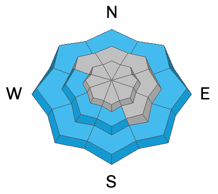
Today, there is a MODERATE avalanche danger on mid and upper elevation steep terrain where it will be possible to trigger 1-2' thick soft and hard slabs of wind drifted snow. The avalanche danger is LOW in lower elevation terrain.
With an additional 1"-4" of new snow overnight and more snow forecast today in the Ogden Area Mountains watch for and avoid sluffing of the newest snow in steep terrain, and avoid wet snow with afternoon warming at lower elevations.
Low
Moderate
Considerable
High
Extreme
Learn how to read the forecast here
Special Announcements
We are seeking a passionate individual to join us as Executive Director of the nonprofit Utah Avalanche Center.
Weather and Snow
This morning, under overcast skies trailhead temperatures are in the low 30's °F and ridgetop temperatures are in the low-20s °F. Winds continue to blow from a southwesterly direction in the teens to the mid 20's MPH at the lower elevation ridgelines and in the 20's gusting to 40's MPH at the highest elevations. Overnight the max gust at 9,200' was 50 MPH from the west-southwest. There was 1"-5" of new snow with .10"-.40" water reported overnight.
Today, look for overcast skies with winds blowing from a westerly direction 15 gusting to 20 MPH at the lower ridgelines and 25 gusting to 30 MPH at the 9,000' ridgelines and decreasing through the day. Temperatures should be 32-38°F with light snow accumulations of a trace to an 3" throughout the day. The freezing level will be between 6500'-7,500'.
Today should be the warmest day of the week as light snow continues through Thursday evening. The travel has remained soft on northerly facing terrain out of the wind zone. Lower elevations and south through west facing slopes at mid elevations took some heat yesterday and you may find a melt-freeze crust on these aspects.
Recent Avalanches
Yesterday we had reports of sensitive cornices and soft shallow wind slabs below ridgetops on the leeward side of terrain features in the Ogden Area Mountains. Check out all observations HERE.
Ad
Avalanche Problem #1
Wind Drifted Snow
Type
Location
Likelihood
Size
Description
The ongoing strong winds that have and continue to blow have transported snow and, in many places stripped some windward locations back to rocks and brush. All of this blowing snow had to go somewhere and there are large drifts of snow on the leeward aspect of ridgelines and terrain features. The hardness of these wind drifts seemed to increase with elevation, which means they are more likely to allow you to get further onto the slope before breaking above you.
Cornices are a sign of fresh wind-loading and there were observations of sensitive and large cornices over the last few days.
Yesterday on the North Ogden Divide B. Smith found sensitive cornices and soft slabs of wind-drifted snow (video below).
Avalanche Problem #2
Wet Snow
Type
Location
Likelihood
Size
Description
Today's warming temperatures mean the lowest elevation terrain will warm up quickly. Stay off of any slopes where you see wet loose rollerballs or start to sink down into the surface snow on steeper terrain. Your best bet is to head to higher elevation terrain if you notice warming at the lowest elevation. Steep chutes and rocky gully features are places where you may see avalanches start as dry loose and very quickly turn into wet snow avalanches.
Additional Information
Come join Snowbasin Ski Patrol and Wasatch Backcountry Rescue for an Avalanche Dog Fundraiser on Saturday, March 9 at 6 PM at the Union Grill (315 24th Street, Ogden UT).
General Announcements
This information does not apply to developed ski areas or highways where avalanche control is normally done. This forecast is from the U.S.D.A. Forest Service, which is solely responsible for its content. This forecast describes general avalanche conditions and local variations always occur.