31st Annual Backcountry Benefit - September 12th - Tickets Available Here!

Forecast for the Salt Lake Area Mountains

Drew Hardesty
Issued by Drew Hardesty on
Tuesday morning, March 5, 2024
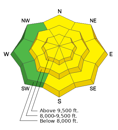
Areas of MODERATE avalanche danger exist on many steep wind drifted slopes across the compass.
You can still trigger pockets of 1-2' thick soft and hard slabs of wind drifted snow even along the low elevation bands in exposed terrain. Keep an eye on the sluffing of the newest lower density snow in steep terrain.
Low
Moderate
Considerable
High
Extreme
Learn how to read the forecast here
Special Announcements
We are seeking a passionate individual to join us as Executive Director of the nonprofit Utah Avalanche Center.
Weather and Snow
Skies are mostly cloudy.
Winds are from the west, blowing 15-20mph. The highest ridgelines have hourly wind speeds of 25-30mph with gusts to 40. Temperatures are in the low teens. Many areas picked up an additional 3-6" yesterday of low density snow and riding conditions are excellent in the wind-sheltered terrain.

One more day of wind, people.
A weak warm front will keep skies mostly cloudy to overcast with possibly an additional trace to 2" today. Temperatures will continue to rise to the low to mid-20s. Winds will blow from the west southwest 15-20mph. Ridgetop anemometers north of I-80 will see hourly wind speeds of 25-35mph+. Another weak system may provide the Logan area mountains a few more inches tomorrow with a splitting system on Thursday providing the mountains of northern Utah another 3-6". Perhaps a touch more. Skies start to clear Friday into Saturday with more unsettled weather on tap for next week.
Recent Avalanches
Ski area avalanche teams reported triggering shallow soft slabs of wind drifted snow 12-24" thick in the mid and upper elevation starting zones with ski cuts and explosives. We didn't hear of any avalanches triggered in the backcountry.
Ad
Avalanche Problem #1
Wind Drifted Snow
Type
Location
Likelihood
Size
Description
Winds at all elevations have been moderate to strong for days now...and those winds have had plenty of snow available for transport. As a result, these strong swirling and eddying winds have deposited soft slabs around the compass...and avalanches have been triggered around the compass. Some of these avalanches have run on structural weaknesses adjacent to the dust layer from March 1st. Target this layer with your snow tests today.
While these soft and occasional hard slabs will be increasingly spotty and stubborn today, I would continue to treat any wind drifted terrain with caution: Let the winds subside, allow for settlement and bonding to occur, and for the snow to stabilize. We will be trending toward Low danger soon.

Cornices are becoming unruly and may break back further than you might expect. Give them a wide berth.
General Announcements
This information does not apply to developed ski areas or highways where avalanche control is normally done. This forecast is from the U.S.D.A. Forest Service, which is solely responsible for its content. This forecast describes general avalanche conditions and local variations always occur.