31st Annual Backcountry Benefit - September 12th - Tickets Available Here!

Forecast for the Skyline Area Mountains

Brett Kobernik
Issued by Brett Kobernik on
Thursday morning, January 11, 2024
IT IS DANGEROUS OUT THERE AND THE WORST IS YET TO COME!!
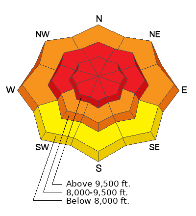
The danger is rated at HIGH for the Manti Skyline. Human triggered avalanches are almost certain today.
Backcountry travel is not recommended.
Low
Moderate
Considerable
High
Extreme
Learn how to read the forecast here
Avalanche Warning
What
The avalanche danger for the warning area is HIGH.
When
In effect from 6am MST this morning to 6am MST Friday.
Where
For the mountains of northern and central Utah and southeast Idaho, which includes the Wasatch Range...the Bear River Range...Uinta Mountains...Manti-Skyline plateau...and the Mountains of Southwestern Utah.
Impacts
Strong winds and heavy snowfall have created widespread dangerous avalanche conditions. Both human triggered and natural avalanches are likely. Stay off of and out from under slopes steeper than 30°.
Weather and Snow
Current Conditions: Wow, we received another good shot of snow last night. The Fairview zone picked up 6 to 8 inches of new snow. The central and southern Skyline did better with 10 to 15 inches overnight. The wind was gusty on Wednesday and was blowing and drifting snow. It has dramatically slowed now. The direction has been mostly from the west. Temperatures were in the mid teens on Wednesday and dropped back into the single digits overnight. Riding conditions were ok on Wednesday. The newest snow was thicker and more dense than what we've seen. It was somewhat "upside down" but still provided some fun turning conditions. Today's snow should be quite good quality.
Mountain Weather: We'll see some lingering light snowfall today with mostly cloudy skies. Temperatures won't get much warmer than about 10˚F. Wind will be light to moderate in speed from the west northwest, gradually increasing later today. The next storm system starts to move in Friday and will last through the weekend potentially bringing a significant amount of snow.
Recent Avalanches
I did not find any new avalanches on Wednesday but visibility was poor and travel was difficult. We are close to a significant natural avalanche cycle if it didn't occur overnight last night.
Ad
Avalanche Problem #1
Persistent Weak Layer
Type
Location
Likelihood
Size
Description
Our situation is very straightforward. The snowpack has a weak base and we continue to load more new snow on top of it. It won't take it for much longer before catastrophic failure. It is imperative to avoid being on any steep slope and avoid being below steep slopes as well. Sooner or later we will be able to trigger avalanches from a distance, maybe it's today. The likelihood of triggering an avalanche and the size of the avalanche is increasing with each snow storm. And it's going to get worse through the weekend.
General Announcements
This forecast is from the U.S.D.A. Forest Service, which is solely responsible for its content. This forecast describes general avalanche conditions and local variations always occur.