31st Annual Backcountry Benefit - September 12th - Tickets Available Here!

Forecast for the Skyline Area Mountains

Brett Kobernik
Issued by Brett Kobernik on
Monday morning, January 29, 2024
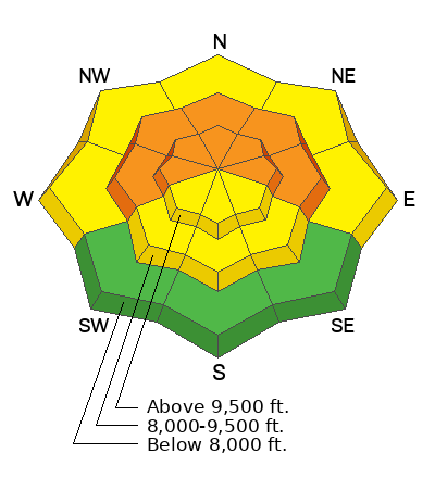
The avalanche danger is rated CONSIDERABLE on steep slopes in the mid and upper elevations that face west, north and east.
Weak snow at the base of the snowpack is still very capable of avalanching especially in areas with a shallower snowpack.
Continue to avoid steep slopes until the weak snow at the base stabilizes.
Low
Moderate
Considerable
High
Extreme
Learn how to read the forecast here
Special Announcements
MOTORIZED BACKCOUNTRY 101 AVALANCHE CLASS
One evening of online presentations, one full day out in the backcountry with instructors.
You'll learn all the basics of rescue and how to read the snow and make good decisions in avalanche terrain.
Hosted by the Utah Avalanche Center
Feb 2nd and 3rd - MORE DETAILS HERE
Weather and Snow
Current Conditions: The sunny skies have been really nice and riding conditions aren't bad. There's plenty of soft dense snow on northerly facing terrain to provide nice turning. You'll find sun crusts on the sunny aspects and lower elevations. The most frustrating part is there are still many areas that are shallow where you punch through deep into the snowpack. It's like the bottom drops out. High temperatures have been remarkable getting into the mid to upper 40s. Overnight lows were in the mid to upper 20s. The wind has been light.
Mountain Weather: High pressure continues through Wednesday with very warm daytime high temperatures. Today looks like the warmest with highs into the mid to upper 40s. Wind will be light from the north. Tuesday and Wednesday are fairly similar only slightly cooler with wind from the south. A series of storms start to move through Friday but they look pretty unimpressive for our area. We'll probably see some snow but for the most part these storms are tracking way too far south to really produce much here.
Ad
Avalanche Problem #1
Persistent Weak Layer
Type
Location
Likelihood
Size
Description
As time goes on, the snowpack adjusts to all the snow from mid January and the chances for triggering an avalanche become less. However, the snow at the base of the snowpack remains very weak. In areas where the snowpack is shallower, the whole structure is weaker and these are the places you're likely to trigger an avalanche. If you find that you are sinking deep into the snowpack while traveling (skis diving deep or track dropping through), this is a clue that you are probably in a shallow, weak area.
I have zero tolerance for faceted snow at the base of the snowpack. It is way too unpredictable. My personal strategy is to simply avoid steep terrain until the snow at the base gains strength.
General Announcements
This forecast is from the U.S.D.A. Forest Service, which is solely responsible for its content. This forecast describes general avalanche conditions and local variations always occur.