31st Annual Backcountry Benefit - September 12th - Tickets Available Here!

Forecast for the Skyline Area Mountains

Brett Kobernik
Issued by Brett Kobernik on
Saturday morning, January 6, 2024
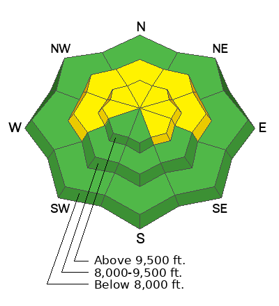
The overall avalanche danger on the Skyline is MODERATE. Human triggered avalanches are possible and are most likely on steep slopes that face north through east just below wind exposed ridges. The danger is less pronounced in wind sheltered terrain.
Low
Moderate
Considerable
High
Extreme
Learn how to read the forecast here
Weather and Snow
Current Conditions: Again, this little weather disturbance that's been moving through exceeded my expectations with up to 8 inches of new snow in the last 24 hours. The central and southern Skyline have been favored in the northwest flow with totals since Thursday in the 10 to 14 inch range. The north end around Fairview Canyon is at about 7 inches new since Thursday. The wind has been fairly well behaved but it has been a little breezy from the northwest along the higher exposed ridges. Temperatures stayed in the teens on Friday and dropped down to around 10˚F overnight.
Mountain Weather: We'll have a break in the snowfall today with cloudy skies, high temperatures in the upper teens to around 20, and decreasing wind from the west northwest. The flow shifts this afternoon and wind will be from the southwest. It will bump up in speed a bit but I'm not expecting it to get all that strong. Another storm moves in tonight that should bring another decent amount of snow. There is one component with the storm that may not be favorable for maximum snowfall but we should see at least 5 inches of new snow by Monday and perhaps up to 10 inches if all goes well. Another storm is advertised for midweek.
Ad
Avalanche Problem #1
Wind Drifted Snow
Type
Location
Likelihood
Size
Description
Any avalanche danger today will be associated with areas where the wind has drifted snow. Triggering an avalanche is most likely on steep slopes that face north through east just below the ridgelines where the wind has deposited new snow. If you feel the snow getting thick or if you see shooting cracks, these are red flags and you should avoid steep slopes.
Avalanche Problem #2
Persistent Weak Layer
Type
Location
Likelihood
Size
Description
We have a Persistent Weak Layer in place but in most locations, we don't have a slab of snow on top of it yet. The new snow is low density and is just as fluffy as the weak sugary snow underneath it. Once we add a little more snow or the wind blows more, we'll see this Persistent Weak Layer come to life. It could be a little tricky to know exactly when the tipping point is, so be on your guard. Collapsing or "Whoomping" of the snowpack underneath you is a clue and a BIG red flag. Bottom Line: it's going to get dangerous at some point.
General Announcements
This forecast is from the U.S.D.A. Forest Service, which is solely responsible for its content. This forecast describes general avalanche conditions and local variations always occur.