31st Annual Backcountry Benefit - September 12th - Tickets Available Here!

Forecast for the Skyline Area Mountains

Brett Kobernik
Issued by Brett Kobernik on
Tuesday morning, January 9, 2024
THE AVALANCHE DANGER WILL BE INCREASING OVER THE NEXT FEW DAYS.
The danger is rated at CONSIDERABLE for the Manti Skyline. Natural and human triggered avalanches are expected as windy storms move through over the next few days.
Avoid being on or below slopes steeper than 30 degrees.
Low
Moderate
Considerable
High
Extreme
Learn how to read the forecast here
Avalanche Watch
...THE FOREST SERVICE UTAH AVALANCHE CENTER IN SALT LAKE CITY HAS ISSUED A BACKCOUNTRY AVALANCHE WATCH WHICH IS IN EFFECT FROM 6AM MST TUESDAY TO 6AM MST FRIDAY.
* WHAT...THE AVALANCHE DANGER IS EXPECTED TO REACH HIGH.
* WHERE...FOR THE MOUNTAINS OF NORTHERN AND CENTRAL UTAH AND SOUTHEAST IDAHO, TO INCLUDE THE WASATCH RANGE...THE BEAR RIVER RANGE..UINTA MOUNTAINS...AND THE MANTI-SKYLINE PLATEAU.
* WHEN...IN EFFECT FROM 6AM MST TUESDAY TO 6AM MST FRIDAY.
* IMPACTS...EXPECTED STRONG WIND AND HEAVY SNOWFALL WILL CREATE WIDESPREAD AREAS OF DANGEROUS AVALANCHE CONDITIONS. BOTH HUMAN TRIGGERED AND NATURAL AVALANCHES ARE LIKELY.
Weather and Snow
Current Conditions: Heads up, the wind speeds have increased. It's not crazy yet but definitely notable with speeds into the 40s along the highest terrain. Backcountry travelers in Ephraim Canyon on Monday noted drifting snow already happening. Temperatures are down around 5˚F. Riding conditions are decent but you'll definitely notice that in many areas you punch through the new powder deep into the baseless weak sugar at the bottom of the snowpack.
Mountain Weather: Hang on, it looks like it's going to get windy. Wind from the west northwest will gradually increase in speed today and will be very strong by tonight. Temperatures will get up to around 20˚F then drop back into the single digits tonight. We should see a few inches of new snow tonight then a better chance for more snow Wednesday night, again accompanied by strong wind.
Recent Avalanches
There was more avalanche activity spotted on Monday. These slides released sometime on Sunday during the storm. They are still "pockety" in nature and are not all that large.............yet.
Electric Lake Bowl, photo Scott Paine:
Ad
Avalanche Problem #1
Persistent Weak Layer
Type
Location
Likelihood
Size
Description
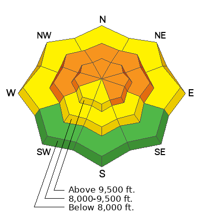
The writing is on the wall. We have weak sugary snow at the base of our snowpack. We've added a bunch of snow and we are starting to see some avalanche activity. With more snow and wind, things will continue to get more dangerous. It is time to avoid being on and below steep slopes for a while. The danger is most pronounced on west through north through east facing slopes at the mid and upper elevations.
General Announcements
This forecast is from the U.S.D.A. Forest Service, which is solely responsible for its content. This forecast describes general avalanche conditions and local variations always occur.