31st Annual Backcountry Benefit - September 12th - Tickets Available Here!

Forecast for the Uintas Area Mountains

Craig Gordon
Issued by Craig Gordon on
Saturday morning, March 2, 2024
An extremely rowdy storm churns away and should land into the Uinta zone midday... the avy danger quickly ramps up once the storm settles in-
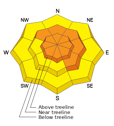
In meteoric fashion, I expect the avalanche danger rises from MODERATE to CONSIDERABLE with the rapid onset of snow, water, and continued wind. Once the storm settles in, both human triggered and natural avalanches are LIKELY on steep, mid and upper elevation, wind drifted slopes. Becoming more the exception than the rule, we can still trigger a deep, dangerous slide that breaks to the ground in steep, rocky terrain facing the north half of the compass.
Even lower elevation slopes come to life with fresh drifts and rapidly accumulating snow. Anticipate the avalanche danger rising to MODERATE around our trailheads with human triggered avalanches POSSIBLE this afternoon.
Low
Moderate
Considerable
High
Extreme
Learn how to read the forecast here
Special Announcements
We are seeking a passionate individual to join us as Executive Director of the nonprofit Utah Avalanche Center. Click here for more information.
Weather and Snow
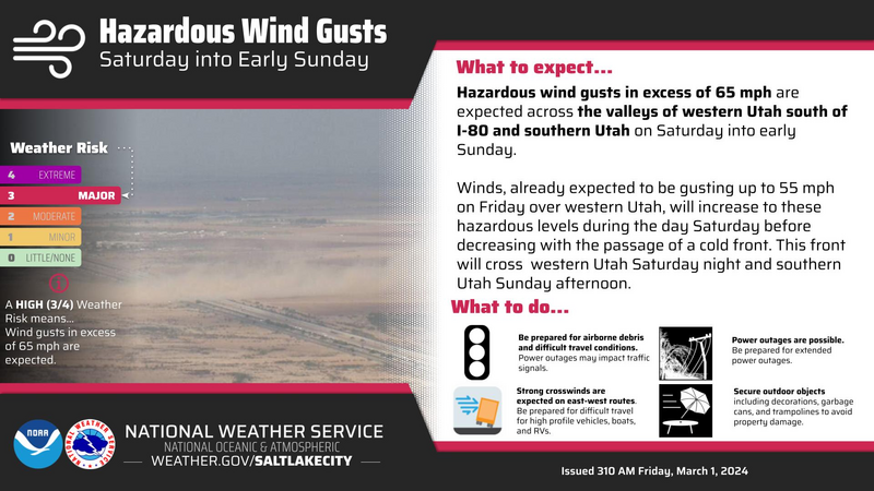
Nowcast- Backyard trampolines take flight and land in nearby states, there's no cows left to tip over, and all the semis in my neighborhood lay on their sides, as 70 mph winds, blowing from the south, pummel the ridges and penetrate into lower elevation terrain. With thick clouds overhead, temperatures are rather mild and register in the low to mid 20's. The snow surface has taken a hard hit and I'd opt for a morning of chores, wait for some snow to stack up, and consider a late afternoon dust patrol.
Forecast- The Lion of Zion roars this morning, as southerly winds blast into the 70's and 80's near the ridges, while mid and low elevation terrain gets raked by winds in the 40's. A cold front slams into the region by late afternoon, temperatures free-fall, we may see lightening, and yes... even thundersnow! Winds shift to the west and northwest and the mountains light up with very heavy snowfall once the front arrives. Look for a foot of snow stacking up by late tonight.
Futurecast- A solid looking shot of snow continues through the night and into early Sunday along with very cold temperatures that barely crack out of the single digits. A short-lived break is on tap for Sunday morning, but another round of storminess slides through the region midday and keeps the party going.
Along with the hazardous winds, our good friends and longtime partners at Salt Lake's National Weather Service issued a Winter Storm Warning for the Uinta zone

SNOTEL sites in the Uintas, and much are Utah, report snow water equivalent amounts of 104%-146% of the 30 year median.
Recent Avalanches
No significant avy activity yesterday. Below are a couple highlights from Thursday-
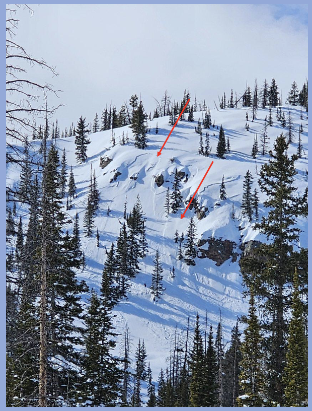
Reported from the Duchesne Ridge Thursday, this remotely triggered slide (from a distance), most likely failed on faceted snow near a heat crust buried by Tuesday's storm snow. A big red flag, especially with more snow, water, and wind on tap.
In addition, avy-savvy, snowpro Joey Manship found a similar, yet not as well connected, piece of snow near Castle Peak.
For all Uinta observations and recent avalanche activity click HERE.
Ad
Avalanche Problem #1
Persistent Weak Layer
Type
Location
Likelihood
Size
Description
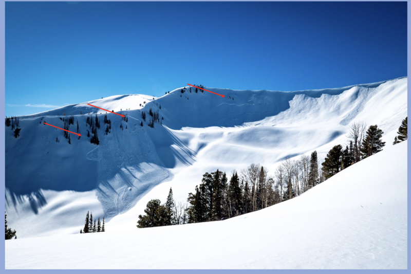
A repeater avalanche path in Weber Canyon, this east facing slope in the alpine came to life with Tuesday's snow and wind, delivering several avalanches that broke close to the ground in steep, rocky terrain.
While much of our terrain offers a deep and relatively strong snowpack, sorta like what Ted and I found Thursday in Upper Chalk Creek, today's big storm will reveal any weak cards in the deck. Remember, slopes that have remained thin and weak this season are likely suspects and need to be avoided. Terrain that has avalanched multiple times and slopes that have been stripped by strong winds fit into this category. Avoiding this unruly and very dangerous avalanche dragon is the ticket, but ya gotta do your homework and identity terrain with shallow snow.
Note to self-
Steep, rocky zones are likely trigger points because they offer a much thinner snowpack where we can effect the weak snow.
Avalanche Problem #2
Wind Drifted Snow
Type
Location
Likelihood
Size
Description
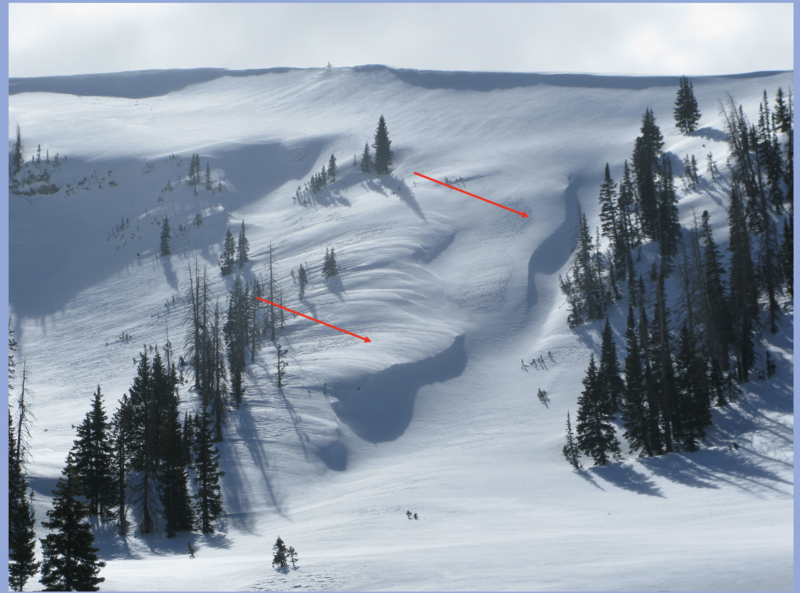
Recent strong winds blew from nearly every direction, whipping up drifts on leeward slopes and cross loading terrain features like chutes and gullies.
Winds are all over the map, drifting snow in unusual locations and lower down-slope than we expect to see. Once the storm kicks in, fresh drifts will react to our additional weight and may break deeper and wider than we'd expect. I'd avoid any fat looking, round pillow of snow, especially if it sounds hollow like a drum.
Avalanche Problem #3
New Snow
Type
Location
Likelihood
Size
Description
New snow rapidly stacks up on a variety of old snow surfaces and we can expect shallow, storm snow avalanches quickly materializing once the storm kicks into gear. Generally manageable in size, remember... even a small slide is dangerous if it stacks snow deeply in a terrain trap like a gully, road cut, or stream bed.
Additional Information
The Uinta weather station network was upgraded this summer and all that real-time info is found HERE. Simply click on "western Uinta" tab and then "weather stations" tab.

We are always looking for snow and avalanche observations or just general riding conditions. So... if you see something, say something. You can reach me directly at [email protected] or 801-231-2170.
Also, if you're looking for more avy education opportunities for yourself, your crew, or your club please don't hesitate to reach out to me and we'll find a presentation, class, or clinic for ya!
General Announcements

Issued at 0400 on Saturday, March 2nd this forecast will be updated by 0700 Sunday, March 3rd, 2024.
This forecast is from the U.S.D.A. Forest Service, which is solely responsible for its content. This forecast describes general avalanche conditions and local variations always occur.