31st Annual Backcountry Benefit - September 12th - Tickets Available Here!

Forecast for the Salt Lake Area Mountains

Drew Hardesty
Issued by Drew Hardesty on
Monday morning, January 8, 2024
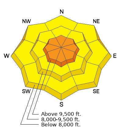
Most terrain has a MODERATE avalanche danger. Human triggered avalanches are possible. Evaluate snow and terrain carefully today.
In the higher elevations, you'll find areas of CONSIDERABLE for soft slabs of wind blown snow. Some of these soft slabs may be triggered at a distance. Pay close attention to shooting cracks or any audible collapsing. Where there is not a cohesive slab, you will be able to trigger longer running loose snow sluffs in steep terrain.
Low
Moderate
Considerable
High
Extreme
Learn how to read the forecast here
Special Announcements
New UAC Product! Sign up HERE for forecast region-specific text message alerts. You will receive messages about changing avalanche conditions, watches, and warnings.

Wondering what happened to the mid-pack PWL? Curious how the December dry spell will play out? Interested in what factors determine future stability trends? Please join UAC forecaster Craig Gordon at 6:00 on Thursday January 11th, at the Kimball Junction library for a FREE State of the Snowpack presentation. More INFO
Weather and Snow
Skies are partly cloudy.
Winds are generally light from the north-northwest, blowing 10-15mph with gusts to 25. Along the highest elevations overnight, the winds averaged 25-30mph with gusts to 45, but they've lost a bit of steam in the last couple hours. Mountain temperatures are in the single digits and below zero at 11,000'. Wind chill there is -24°F.
Snow report: With an additional 1-3" overnight, storm totals are roughly 5-10" with upwards of 0.40" of snow-water-equivalent. The Ogden mountains picked up 10-15" (0.75"SWE); the Provo mountains generally 5-12" (0.62"SWE) of new snow.
For today, we'll have partly cloudy skies, light winds from the northwest, and temps in the single digits. Increasing clouds tonight.
For tomorrow and through the end of time, I'll only remind you, Be careful what you wish for. We have a very active weather pattern on deck with a series of storms starting tomorrow afternoon. Temperatures warm to the upper teens to low 20s tomorrow as the westerly winds (from the west) amp up and become strong Tuesday afternoon. Light snowfall should begin midday. By the end of the weekend, we'll be measuring the snowfall in terms of feet, not inches.
Recent Avalanches
Avalanche activity yesterday remained spotty and inconsistent. Ski area control teams and observers reported mostly longer running sluffs with occasional soft slabs in the wind zone.
The canary in the coal mine is Saturday's remotely triggered soft slab avalanche in Main Porter Fork of Mill Creek Canyon (below). A backcountry traveler remotely triggered an avalanche that failed on our PWL (persistent weak layer) of facets a foot deep and 60' wide on a steep northeast facing slope at 9100'. It broke above him and he was briefly carried down the slope.
Ad
Avalanche Problem #1
Wind Drifted Snow
Type
Location
Likelihood
Size
Description
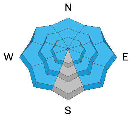
You'll find sensitive soft slabs of wind drifted snow on a variety of aspects and primarily (but not exclusively) in the upper elevations. Winds blew moderate to strong from the southwest prior to frontal passage Saturday night and then shifted to the northwest yesterday. They have been blowing in the moderate category from this direction ever since with more than enough snow to transport into cohesive slabs. Avoid these rounded rippled whales of wind blown snow. Shooting cracks are a tell-tale sign of instability. ⚠️ They may also break out above you on a slope.
Avalanche Problem #2
Persistent Weak Layer
Type
Location
Likelihood
Size
Description
The December drought layer PWL of weak sugary facets is now capped by 6-18" of low density snow. In most areas, this new snow has yet to become enough of a cohesive slab to result in widespread avalanches. Instead, this low density snow has avalanched as dry loose new snow avalanches, often gouging into the weak sugar below. Saturday's Porter Fork avalanche currently is more the exception than the rule, but we're walking on eggshells now because it's not IF but WHEN this type of avalanche does become the rule. With tomorrow's wind and storms lined up, that time will be very soon. Currently, I have rated the danger as MODERATE...human triggered avalanches are possible.
TAKE NOTE that the Ogden mountains received more snow and more wind and the danger spiked to HIGH yesterday with slab avalanches triggered in all the elevation bands (as low as 5700') on many aspects. This to me serves as the cautionary tale for the central and southern Wasatch.
General Announcements
This information does not apply to developed ski areas or highways where avalanche control is normally done. This forecast is from the U.S.D.A. Forest Service, which is solely responsible for its content. This forecast describes general avalanche conditions and local variations always occur.