31st Annual Backcountry Benefit - September 12th - Tickets Available Here!

Forecast for the Uintas Area Mountains

Craig Gordon
Issued by Craig Gordon on
Saturday morning, January 20, 2024
The snow may feel Bomb dot Com under our skis, board, or sled... however, it's far from straight-forward and the jury is still deliberating. What I do know is... guilty until proven othewise. Avalanches are getting harder to trigger, but can break to a persistent weak layer of snow now buried several feet deep in our snowpack, resulting in a catastrophic slide.
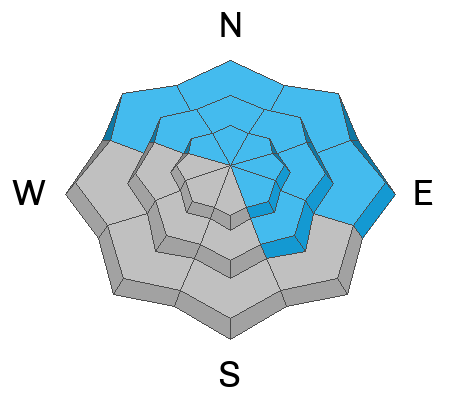
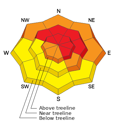
Not as widespread as a few days ago, HIGH avalanche danger still exists on steep, upper elevation slopes and it's particularly sketchy on leeward slopes in the windzone at and above treeline. Human triggered avalanches breaking to deeply buried weak layers are LIKELY in terrain facing the north half of the compass, and especially on slopes with an easterly component to its aspect. Note to self... if I trigger an avalanche it could result in a large and potentially unsurvivable slide.
CONSIDERABLE avalanche danger is found above treeline on the south aspects and below treeline on shady slopes where human triggered avalanches are PROBABLE. In either case, a midpack weak layer remains suspect and is guilty until proven otherwise.
Mid and lower elevation terrain facing the south half of the compass delivers MODERATE avalanche danger and human triggered avalanches are POSSIBLE on steep, wind drifted slopes.

Here's your exit strategy-
We need to continue steering clear of terrain with overhead hazard and that means... avoid being on, under, or connected to steep slopes where we could potentially pull the rug out from underneath and crash the roof down on top ourselves.
Low
Moderate
Considerable
High
Extreme
Learn how to read the forecast here
Weather and Snow
Nowcast- Like a thin, Merino wool beanie worn for looks not function, high clouds drift through the area this morning, putting a lid on temperatures which start their weekend in the mid and upper 20's. Winds from the southeast began bumping into 20's at the turn of the new day and continue in that spirit at O'dark Thirty near the high peaks. Our recent storm snow took a bit of a hit with yesterday's sunshine and lower elevation sunny slopes are gonna have a thin heat crust. But don't let your heart be troubled... gain a little elevation and snag a low angle shady slope with no overhead hazard and you'll be rewarded for your efforts.
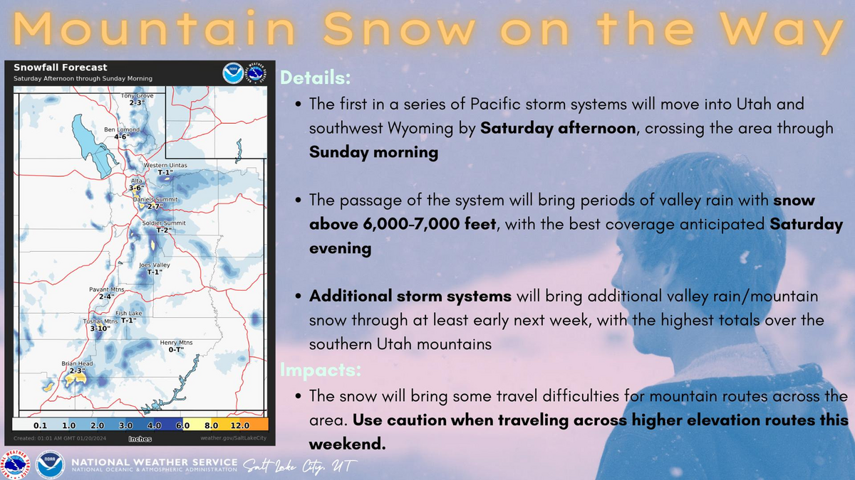
Forecast- Kinda low energy day... if there's such a thing as low energy :) Look for mostly cloudy skies with temperatures climbing into the mid and upper 30's. Winds blow from the south in the 20's and 30's, peaking into the 40's along the high ridges for late in the day. Snow develops around dinnertime with 3"-6" expected for Sunday service.
Futurecast- Another storm in the queue for Sunday probably dives south, delivering cloudy skies and a stray snow shower or two for the Uinta zone. A break is slated for Monday with a shallow refresh on tap for Tuesday.

Snow summary from NRCS SNOTEL sites:
Chalk Creek #1 (9,171') - 50" snow depth (10.7" total water)
Trial Lake (9,992') - 58" snow depth (10.6" total water)
Wolf Creek Peak (9,796') - 41" snow depth (8.6" total water)
Currant Creek (7,915') - 30" snow depth (7.7" total water)
Daniels-Strawberry (8,008') - 37" snow depth (8.6" total water)
Strawberry Divide (8,123') - 46" snow depth (11.2" total water)
Recent Avalanches
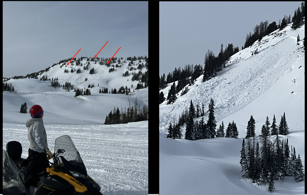
Bayou Dave reported this curious avalanche yesterday afternoon on a Southeast aspect at 10,400' in Upper Humpy Basin. I'm unsure if these two pockets, breaking 2'-3' deep and 300' wide, occurred naturally or were triggered remotely, from a distance, but will confirm today and report back for tomorrow's update.

Read more Uinta observations and avalanches HERE.
Ad
Avalanche Problem #1
Persistent Weak Layer
Type
Location
Likelihood
Size
Description
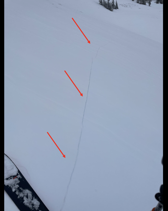
Young Guns 3 rising star, avy-savvy Trevor Katz, stomped around in Upper Humpy Basin yesterday and reports a tightly wound slab resting on weak snow and says... "Photo of the crack is after I collapsed what sounded like all of the entire basin. Thundering... "
Here's the setup-
A dense, cohesive slab rests on top of weak, sugary snow developed during the mid December dry spell... strong snow on weak snow. It's a dangerous combo because the snow feels solid underneath us, suggesting we're good to go. In fact, we'll be able to get well out onto a slope before we kick the legs out from underneath and trigger a slide that breaks much deeper and wider than we might've bargained for. And once triggered, we're gonna be staring down the barrel of a very dangerous avalanche. The key to longevity is in our hands... we just need to recognize we're slowly trending in the right direction, but the snowpack still needs some time to adjust to last weeks big storm. There's plenty of lower angle terrain out there where we can have a blast. So, let's keep it tight and not pull the avalanche dragons tail today... guaranteed its bite is worse than its bark!
Avalanche Problem #2
Wind Drifted Snow
Type
Location
Likelihood
Size
Description
Recent and older wind drifts-
Winds were all over the map as last weeks storm began to materialize and we've identified drifting in some unusual locations. While they're beginning to settle and become a bit more stubborn, I bet you can still find a wind drift or two reactive to our additional weight. Found mostly on the leeward side of mid and upper elevation ridges, I suspect you'll also find shallow drifts at lower elevations and around terrain features like chutes and gullies. In addition, there may be a few older drifts that formed late last week as the storm cycle got going. Older drifts are harder to trigger, but once initiated they'll be packing a punch.
In either case, the ticket is to avoid fat rounded pillows of snow, especially if they sound hollow like a drum.
Additional Information
The Uinta weather station network was upgraded this summer and all that real-time info is found HERE. Simply click on "western Uinta" tab and then "weather stations" tab.

We are always looking for snow and avalanche observations or just general riding conditions. So... if you see something, say something. You can reach me directly at [email protected] or 801-231-2170.
Also, if you're looking for more avy education opportunities for yourself, your crew, or your club please don't hesitate to reach out to me and we'll find a presentation, class, or clinic for ya!
General Announcements

Issued at 0400 on Saturday, January 20th this forecast will be updated by 0700 Sunday, January 21st, 2024.
This forecast is from the U.S.D.A. Forest Service, which is solely responsible for its content. This forecast describes general avalanche conditions and local variations always occur.