31st Annual Backcountry Benefit - September 12th - Tickets Available Here!

Forecast for the Logan Area Mountains

Toby Weed
Issued by Toby Weed on
Thursday morning, February 15, 2024
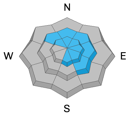
A powerful winter storm with significant accumulations and drifting by increasing winds blowing from the southwest and west will cause CONSIDERABLE danger to develop during the storm today. Dangerous avalanche conditions will become likely in drifted upper and mid-elevation terrain and on slopes steeper than 30° with significant accumulations of heavy new snow. Natural avalanches are possible, and human-triggered avalanches are likely. Loose wet avalanches are possible on steep slopes at lower elevations.
  • Careful snowpack evaluation, cautious route-finding, and conservative decision-making are essential for safe backcountry travel.
  • Avoid and stay out from under slopes steeper than 30° with significant recent deposits of wind-drifted snow, heavy storm snow, or wet new snow.
Low
Moderate
Considerable
High
Extreme
Learn how to read the forecast here
Special Announcements
We are seeking a passionate individual to join us as Executive Director of the nonprofit Utah Avalanche Center. Click here for more information.
Want to learn more about how to stay safe from avalanches while riding in the backcountry? Join us Feb 23-24 for an Introduction to Avalanche class. Information and registration here.
Weather and Snow
Heavy snowfall and drifting will cause rising avalanche danger in the backcountry today, and as snow accumulates and is drifted by strong winds from the west, dangerous conditions will probably develop on upper and mid-elevation slopes.
Heavy snowfall is visible this morning on Beaver Mountain's webcams. The Tony Grove snotel at 8400' reports 5" of new snow overnight with .5" SWE. It's 28° F at the site and there is 83" of total snow. The wind is blowing from the southwest this morning around 35 mph with a 54 mph gust at the 9700' CSI Logan Peak weather station. At 9500' on Paris Peak, winds from the south-southwest are blowing 20 mph with gusts near 40 mph, and it's 21° F.

The National Weather Service has issued a Winter Storm Warning for the Northern Bear River Range and a Winter Weather Advisory for the Logan Zone south of the state line. A winter storm will impact the zone, and significant accumulations and drifting by winds blowing from the west are expected today. 8 inches to a foot of additional new snow could accumulate on upper-elevation slopes by this evening. Temperatures will remain steady, around 24° F at 8500', and 25 to 30 mph winds with much higher gusts will blow from the west.
More snow is expected to accumulate in the in the mountains tonight and more on Friday...
Recent Avalanches
A snowmobiler triggered a wind slab avalanche Saturday on the northeast side of Bloomington Peak. No other significant avalanches were reported recently in the Logan Zone
Check out local observations and avalanches HERE.
Ad
Avalanche Problem #1
Wind Drifted Snow
Type
Location
Likelihood
Size
Description
Drifting by winds from the southwest and west will increase the avalanche danger during the day today. Natural avalanches of wind-drifted snow will be increasingly possible in exposed upper-elevation terrain, and people are likely to trigger wind slab avalanches on drifted slopes.
  • Watch for and avoid fresh and forming wind slabs on the lee side of major ridges on corniced slopes and in and around terrain features like cliff bands, sub-ridges, gully walls, and mid-slope rollovers.
  • Stay well away from and out from under overhanging cornices, which are growing today and may break further back than expected.
Avalanche Problem #2
New Snow
Type
Location
Likelihood
Size
Description
Loose and soft slab avalanches of storm snow will become more likely as heavy snow accumulates on steep slopes during the day. Natural loose wet avalanches entraining big piles of heavy rain-saturated or soggy new snow are possible in steep lower-elevation terrain.
  • Natural avalanches are most likely during periods of particularly heavy snowfall, and rapid accumulations will also make avalanches more easily triggered by people.
  • People should avoid being in avalanche paths and stay off and out from under steep slopes with significant accumulations during periods of heavy snowfall.
  • People should avoid being under steep lower-elevation slopes with saturated or heavy, sloppy new snow. Choose fishing holes and dog walking areas that are out from under steep slopes.
Additional Information
Here is a short video showing the deep and stable snow we found during Wednesday's field day in the Cub River Area. Our main concerns moving forward will be centered around new snow and wind-related avalanche problems.
General Announcements
-Listen to your very own Logan Zone avalanche forecasters on the UAC Podcast HERE.
-Read Toby's recent blog about wind, drifting, and avalanches HERE.
-Sign up for forecast region-specific text message alerts. You will receive messages about changing avalanche conditions, watches, and warnings...HERE.
-For all questions on forecasts, education, Know Before You Go, events, online purchases, or fundraising, call 801-365-5522.
-To report an avalanche or submit an observation from the backcountry, go HERE.
-Come practice companion rescue at the Franklin Basin TH Beacon Training Park. It's free and open to everyone. For easy user instructions, go HERE.
-We will update this forecast by 7:30 AM tomorrow.
This forecast is from the U.S.D.A. Forest Service, which is solely responsible for its content. This forecast describes general avalanche conditions, and local variations always occur.